
Select NOAA-NWS Forecast Office Text Products
(Product availability varies with seasons, forecast office, and weather.)
Forecast Discussion for Chicago, IL
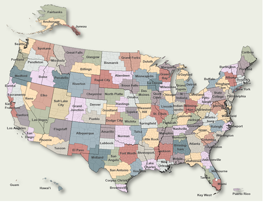
To Select Another NWS Office Click on Map or Choose from List
|
| Select Forecast Office: | Select Product: |
905
FXUS63 KLOT 112334
AFDLOT

Area Forecast Discussion
National Weather Service Chicago/Romeoville, IL
634 PM CDT Thu Jun 11 2026

.KEY MESSAGES...

- Severe storms likely through this evening (highest threat
  between 5 and 10 PM). All hazards (tornadoes, destructive
  winds, significant hail) are possible across the entire area.

- After a dry and cooler day on Friday, there is another threat
  for severe weather late Saturday.

&&

.MESOSCALE...
Issued at 222 PM CDT Thu Jun 11 2026

Quick update on latest thinking regarding today`s severe threat.
The 18z sounding from ILX has shown an impressive EML (elevated
mixed layer) has advected into the area. This is resulting in
MUCH steeper 700-400 mb lapse rates, however at the base of those
steeper lapse rates there`s been about a 2C+ warming in/near
700mb. That warming near 700mb and resultant convection
inhibition combined with weaker large scale ascent (for now) has
prevented the convection near the tail end of the morning MCS from
becoming rooted in the boundary layer and taking off. This bodes
well for reducing the chances for discrete convection in the open
warm sector across central IL.

HRRR continues to lose that convection much more quickly than
what is actually happening, however the WOFS (Warn-on Forecast
System) hangs onto that convection and the lingering footprint
of the cold pool longer than the HRRR. It too, loses that
convection quickly, perhaps a bit too quickly, but generally
depicts that the northern extent of the very concerning tornado
environment later this afternoon would be a farther south. It
wouldn`t be shocking to see that northern extent shift a bit
farther south in later runs as WOFS initializes from current
radar.

Farther west, the low level response the sfc cyclone lifting
northeast has been quite impressive with northward surge of low
level moisture. Cloud cover and precipitation is preventing
boundary layer temps from warming in this area resulting in very
weak low level lapse rates. Farther south, across far northeast
Missouri some breaks in the cloud cover have allowed temps to warm
into the low to mid 80s, resulting stronger low level CAPE.
Satellite trends suggest that some partial clearing will
overspread much of northern IL this afternoon. This combined
with increasing southerly flow in the synoptic response to the
deepening low lifting north in Iowa should result in the
outflow boundary/southern extent of outflow from the morning
convection gradually lifting north and perhaps mixing out a bit
this afternoon.

It still seems like there will be a gradient between stronger
low level CAPE and weaker low level destabilization somewhere in
our CWA. Latest WOFS has the northern extent of that better low
instability and resultant very favorable tornado environment
getting as far north as roughly to an Ottawa to Chicago line by
later this afternoon. While the exactly how far north the more
concerning environment gets is lower confidence (ultimately may
not be a sharp line rather more of a gradient), but the general
idea of significant tornado threat increasing near/south of I-55
and I-80 seems reasonable.

There is a dramatic increase in low and deep layer shear comparing
ILX`s VWP to DVN`s VWP. The unseasonably strong shear noted on
DVN`s VWP is expected to spread eastward across our CWA as the
afternoon progresses. Storm mode may tend to favor linear by the
time the convection reaches our CWA, but given the very strong low
level shear, QLCS tornadoes and perhaps even tornadic supercells
embedded within the QLCS will be a threat. This threat will likely
be more prolific where the stronger boundary layer heating leads
to stronger low level CAPE, but even farther north the strong
shear will support a QLCS tornado threat.

Finally, any discrete supercell within the warm sector later this
afternoon (especially southern CWA) will be in an exceptionally
favorable environment for strong tornadoes. While linear storm
mode is most likely, there is still some chance for discrete
supercell development in the warm sector, so we will be
watching that closely. If the remnant outflow boundary from
this morning`s MCS doesn`t mix out, then it would be a potential
source for enhanced low level vorticity and a zone we`d watch
for a locally higher tornado threat (both supercellular and
QLCS).

- Izzi

&&

.DISCUSSION...
Issued at 242 PM CDT Thu Jun 11 2026

Broad mid and upper-level cyclonic flow will persist across the
northern United States through the period. While this will
maintain periodic opportunities for showers and thunderstorms
into next week, we will experience a brief break in pattern for
Friday. On Friday, a much less humid airmass shifting overhead
on westerly winds in the wake of this evenings cold frontal
passage will support a more comfortable weather day with
temperatures topping out around 80 under mainly sunny skies.

Humidity values will be back on the increase again for Saturday
as the low-level flow turns south-southwesterly in advance of
the next approaching surface cold front dropping southward from
the Upper Midwest. As the front shifts into our area late
Saturday into Saturday night, a narrow corridor of slightly
better low-level moisture return preceding it may support the
development of some scattered showers and thunderstorms. Should
these materialize, we will also have to monitor the potential
for some more organized storms into Saturday evening,
particularly given the presence of strong deep layer flow. While
not looking to be a major severe weather event at this time, we
certainly cannot rule out the threat for a few stronger storms
to become capable of producing instances of damaging winds and
hail. Accordingly, the SPC Day 3 outlook continues to highlight
our area in a level 1 of 5 severe weather threat for late
Saturday.

A push of much cooler and dry weather is anticipated for the
second half of the weekend into early next week following the
cold frontal passage Saturday night. Interestingly, this airmass
looks to hold daytime highs in the 70s (lows in the low to mid
50s) early next week. Conditions then look to turn more active
again (return of showers and thunderstorms) mid to late next
week as an enhanced northwesterly upper-level flow pattern sets
up across the central part of the country.

KJB

&&

.AVIATION /00Z TAFS THROUGH 06Z SATURDAY/...
Issued at 634 PM CDT Thu Jun 11 2026

Key Messages:

- Strong storms impact the terminals through 02-03Z this
  evening. Brief period of gusty winds in excess of 45 kt and
  torrential downpours may accompany these storms.

- Winds shift westerly and gradually abate mid to late this
  evening following a cold frontal passage.

The main aviation weather concern revolves around the strong
thunderstorms that will impact the terminals through 02-03Z
this evening. Very heavy rainfall will accompany these storms,
which will likely result in a short (hour or less) period of
sub mile VSBYs. Also, a period of strong, potentially damaging
wind gusts (in excess of 45 kt) may accompany this line of
storms. Fortunately, the line of storms will quickly shift east
of the terminals after 02-03z this evening as a cold front
shifts across the area. Winds will shift westerly following
this frontal passage, with speeds expected to ease overnight.

Quieter weather is expected overnight and through the day
Friday, with mainly clear skies and westerly winds.

KJB

&&

.LOT WATCHES/WARNINGS/ADVISORIES...
IL...Flood Watch until 11 PM CDT this evening for ILZ003-ILZ004-
     ILZ005-ILZ006-ILZ008-ILZ010-ILZ011-ILZ012-ILZ013-ILZ019-
     ILZ020-ILZ021-ILZ023-ILZ032-ILZ033-ILZ039-ILZ103-ILZ104-
     ILZ105-ILZ106-ILZ107-ILZ108.

IN...Flood Watch until 11 PM CDT /midnight EDT/ this evening for
     INZ001-INZ002-INZ010-INZ011-INZ019.

LM...Small Craft Advisory until 10 PM CDT this evening for the IL
     and IN nearshore waters.

&&

$$

Visit us at weather.gov/chicago
|
Previous Forecast Discussions may be found at
NWS Chicago, IL (LOT) Office Forecast Discussions.
(Click 'Previous Version' there to view past versions successively.
Some may differ only in time posted.)
Products Courtesy of NOAA-NWS
NWS Information Parsing Script by Ken True at Saratoga Weather - WFO and Products Scripts by SE Lincoln Weather.
Mapping by Curly at Michiana Weather and by Tom at My Mishawaka Weather.